|

 |
2
OF 4 |
 |
1513 World Map
 Piri Reis World Map is so valuable piece of the world's cartograph and documentary heritage. The United Nations Educational, Scientific and Cultural Organization (UNESCO) declared 2013 the year of Piri Reis on the occasion of the 500th anniversary of a map he drew up. Piri Reis World Map is so valuable piece of the world's cartograph and documentary heritage. The United Nations Educational, Scientific and Cultural Organization (UNESCO) declared 2013 the year of Piri Reis on the occasion of the 500th anniversary of a map he drew up.
It is said that Piri Reis map was found in 1929 by Director of National Museums Halil Ethem while Topkapi Palace turned into the museum. Biblical scholar Adolf Deismann and The German orientalist Paul Kahle researched and identified the map after it found.
Showing the Atlantic Ocean and surrounding continents in Piri Reis map of 1513 was announced to the world in 1931. The map was exhibited in museums around the world in different maps. Today, the map is preserved in the Topkapi Palace Museum. Due to 500th anniversary of Piri Reis Map as a Piri Reis year 2013, "Piri Reis and the 1513 World Map: 500 Years of Mystery" exhibit which includes works displaying the perception of the world prior to Piri Reis, was held from March 15th to May 31st at the Mimar Sinan Fine Arts University Tophane-i Amire Culture and Arts Center.
Great interest in the international arena include the reason why the first remaining map of America, and since Columbus' map is lost, the only original document the world have is this map of Piri Reis. Piri Reis’s map referred Columbus while drawing American coasts.
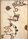
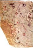
The map is drawn on gazelle skin and illustrated in nine different colours. The map is 86 cm long, 61 cm wide at the upper and 41 cm wide at the lower edge. The map shows mountains in embossed design, the rivers in thick lines and shallow places in red points, stony places with drawnings of common plant, animal pictures, and notes about regions.
The remaining part of the map includes the east and west coasts of Atlantic Ocean as the coastlines of North and South America, the Antilles, Northwest Africa, France and Spain. Map also introduces shores and islands without latitudes. Wind Roses lines and scales are helpful for measuring the distance between ports. There are images of ships on the map to show the discoveries of the travelers.
The map has a major historical value because of its being drawn in terms of much of a scientific approach for its times and present-day scientists still surprises the remaining part of the the map places so close to the precision of the existence of present map.
.
|
2
OF 4 |
|
|