|

 |
3
OF 4 |
 |
The Map of 1528
 Piri Reis worked for the newly discovered places in the west and he prepared his regional map in 1528 after finishing his book “The Book of Bahriye”. According to the studies on this map which shows the areas between the Ottoman Empire and America and its aim drawing an attention of the Ottoman Empire to the geographical discoveries. Piri Reis worked for the newly discovered places in the west and he prepared his regional map in 1528 after finishing his book “The Book of Bahriye”. According to the studies on this map which shows the areas between the Ottoman Empire and America and its aim drawing an attention of the Ottoman Empire to the geographical discoveries.
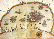
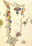
During the researches for the missing parts of Piri Reis’ 1513 Map, Topkapi Palace Museum Director Tahsin Öz found a part of new map. The map features the north of Atlantic and the coasts of North & Middle America discovered at those times. Remaining part is a quarter of the whole and it’s scales are 69.28 x 70.20 cm. According to estimations whole map would have the dimensions of 132 x 138 cm.
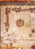
The Map of 1528 was made of gazelle skin and illustrated in eight colors. There are four major wind roses into 32 parts looked into the north in this map. Also two minor wind roses places in this map too. The map starts with Greenland in the north. Tropic of Cancer was drawn over Cuba Island. Cuba and Haiti are also drawn quite in the second map.
Piri Reis’ signature is at the south-west corner of the map as it says; “ The map was drawn in 935 (A.D 1528) by Hakir Piri Reis, son of Haci Mehmed, nephew to late Reis Gazi Kemal of Gallipoli. The work is definetely his.”
The Map of 1528 was presented to the Sultan Suleiman the Magnificent at that era. Today its remaining part is preserved in Topkapi Palace Museum with the 1513 World Map. Map of 1528 is one of the most facinating maps with regard to map technique drawn in that century.
|
3
OF 4 |
|
|