|

 |
4
OF 4 |
|
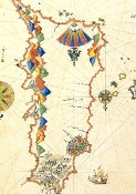
 Piri Reis, 16 centurys famous intelligence, cartographer, scientist, and as big as a researcher, a legendary seafaring captain. He noted several informations in his sea experiences in the first years of maritime studies and making the map of the world in 1513. These studies were gathered Kitab-ı Bahriye as known as The Book of Navigation which was completed in 1521. Piri Reis, 16 centurys famous intelligence, cartographer, scientist, and as big as a researcher, a legendary seafaring captain. He noted several informations in his sea experiences in the first years of maritime studies and making the map of the world in 1513. These studies were gathered Kitab-ı Bahriye as known as The Book of Navigation which was completed in 1521.
The Book of Bahriye depends on observations and researches of Piri Reis and such a valuable cutural heritage for the world history as famous Piri Reis historian Svat Saucek says, describing for navigators the islands and coasts of the Mediterranean and Aegean Sea, Kitab-ı Bahriye is one of the leading works of the science of geography for Ottoman and world history as well as historical cartography.
The conquer time of the Suleiman The Magnificent was very important era of the Ottoman Empire. In 1522 Piri Reis participated to the Siege of Rhodes and in 1524 his duty was the captain of the ship that had a mission for the Ottoman Grand Vizier Pargalı İbrahim Pasha to Egypt. So he gained the support of Ibrahim Pasha. In 1525 he presented his masterpiece The Book of Bahriye to the Suleiman The Magnificient through the Grand Vizier Pargalı İbrahim Pasha.
First part of the Book of Bahriye explains purpose of the writing the book. According to Kemal Özdemirs Ottoman Cartography: Subjects like the necessity of sea sciences for the sailors, the names of the winds and storms, the introduction of the map, signs on the maps, names of sea, the Portuguese sailors who sailed to the Indian Ocean, the Sea of China, the Indian Ocean, the Persian Gulf, Muğti coasts in Ethiopia and Kamur Islands, the Mediterranean, the Strait of Hormuz, the Antilles and the discovery of America were all to Bahriye thus considering all the up-to-date information as well as the political situation.
At the beginning of next part Piri Reis explains the reasons for writing book and describes the Sultaniye and Kilitbahir Fortresses. He then continues to describe Aegean Sea, Greece, the Adriatic Coasts, the Mediterranean coasts of Italy, France and Spain, North Africa, Egypt, East Mediterranean coast, Cyprus and the islands and the ports on the Aegean coast of Anatolia. He concludes the book by describing Saros Gulf, which is located to the north of Gelibolu.
Piri Reis also explains about the depths, anchorage spots, coastal vegetation, drinking water and ship repair possibilities along the coasts. Furthermore, he supplies information about about the people living there, religions and political balance of power. The book also contains archeological and historical data. Piri Reis also recounts some interesting experiences of himself and other captains.
The Book of Bahriye is a masterpiece and guide book for the maritime history. This unique books and the other maps mysteries are discussed yet in our time by the historians.
 |
4
OF 4 |
|
|


