| |

| |
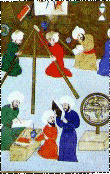 |
| Takiyuddin and Observatory |
|
|

 |
2
OF 2 |
|
From the sixteenth century onwards, noteworthy
geographical works were produced by Pîrî Reis, In 1511, Pîrî Reis
drew his first map. This map is part of the world map prepared on
a large scale. It was drawn on the basis of his rich and detailed
drafts an in addition, European maps including Columbus' map of
America. This first Ottoman map which included preliminary information
about the New World represents south western Europe, north western
Africa, south eastern and Central America. It is a portalano, without
latitude and longitude lines but with lines delineating coasts and
islands. Pîrî Reis drew his second map and presented it to Süleymân
the Magnificent in 1528. only the part which contains the North
Atlantic Ocean and the then newly discovered areas of Northern and
Central America is extant. Pîrî Reis also wrote a book entitled
Kitâb-ı Bahriye (Book of the Sea) (1521). In this work, Pîrî Reis
presents drawings and maps of the cities on the Mediterranean and
Aegean coasts, and gives extensive information about navigation
and nautical astronomy. Admiral Seydî Ali Reis (d. 1562), who wrote
the work in Turkish titled al-Muhit (The Ocean), was a notable figure
of the period in maritime geography. This work contains astronomical
and geographical information necessary for long sea voyages and
his own observations about the Indian Ocean.
Another work of the sixteenth century which
contains information about the geographical discoveries and the
New World is the book entitled Târih-i Hind-i Garbî (History of
Western India). This work, whose author is unknown, was presented
to Sultan Murâd III in 1583. It was based on Spanish and Italian
geographical sources. It is important in showing that the geographical
discoveries of the West were known to the Ottomans. The work has
three parts; the third part which is the most important and which
comprises two thirds of the whole book, relates the adventures of
Columbus, Balboa, Magellan, Cretes, and Pizarro during the sixty
years from the discovery of America in 1492 until 1552 (Goodrich,
1990). Apparently, cartography was organized as a profession in
the Ottoman Empire, for example, in the seventeenth century, fifteen
individuals were occupied with the art of surveying, in eight locations
in Istanbul and nearby areas.
|
2
OF 2 |
|
|
|